Lesson 09 — Plate Tectonics: Continents, Mountains, and Ocean Basins
Learners explain how **plate tectonics** shapes **continents, mountains, and ocean basins** over millions of years. They match the three boundary types — divergent, convergent, transform — to what each builds, and connect the idea to the model-revision story of continental drift.
Objectives
Objectives
- D06.S4.08.02 Explain how plate tectonics shapes continents, mountains, and ocean basins over millions of years.
Essential question
How does plate tectonics shape continents, mountains, and ocean basins over millions of years?
Key vocabulary
Materials
Standard materials
- Plate-boundary sheet · 1 per learner A cross-section diagram of three boundary types — divergent, convergent, transform — to label and annotate
- Boundary cards · 1 set per group Cards for the three boundary types and what each builds (ridge, mountain, trench, fault), to match
Low-tech / no-cost
- A shared board or large paper Draw the three boundaries together with arrows
- Hands as plates Use two hands sliding together, apart, or past each other to feel the three boundary motions
Enriched / lab & device
- A world map of tectonic plates and the Ring of Fire · 1 per group To see where the boundaries run and where earthquakes and volcanoes cluster
- A short animation of plates moving over millions of years · 1 To see continents drift and mountains and ocean basins form
Works in different contexts
- large-group Model the three boundaries once to the whole group with hands, then small groups match boundary cards to what they build
- multi-age Younger learners match a boundary to a landform picture; older learners explain how a mountain or ocean basin forms
- self-directed A learner labels the sheet, matches the cards, and writes one sentence on how a mountain forms over millions of years
- level-grouped Learners ready to extend connect plate tectonics to the earlier lesson on revising models (continental drift → plate tectonics)
- outdoor-only Find a crack, ridge, or slope in the land or rock nearby and discuss the slow forces that shaped it
Lesson 9 — Plate Tectonics: Continents, Mountains, and Ocean Basins
Summary
Learners explain how plate tectonics shapes continents, mountains, and ocean basins over millions of years. They match the three boundary types — divergent, convergent, transform — to what each builds, and connect the idea to the model-revision story of continental drift.
Objectives
- Explain how plate tectonics shapes continents, mountains, and ocean basins over millions of years. (D06.S4.08.02)
Connection
Look at a map of the world and you might notice that the east coast of South America seems to fit the west coast of Africa like two puzzle pieces. That fit is not a coincidence. The ground beneath your feet is not one solid shell — it is broken into great plates that move, so slowly you cannot feel it, carrying continents apart and crashing them together to raise mountains and open oceans. Today you learn how the face of the Earth was sculpted, one slow inch at a time.
Materials
- Plate-boundary sheet
- Boundary cards
Preparation
- Copy the plate-boundary sheet and boundary cards.
- Retrieval: from Grade 5 and 7, recall where earthquakes and volcanoes occur and that the Earth’s surface changes by slow and fast processes; from Lesson 3, recall that models are revised when evidence appears.
Facilitator note
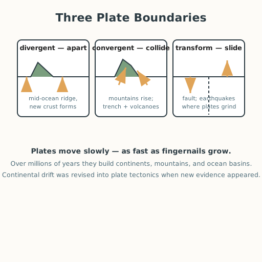
This lesson is written to the learner (“you”). The ideas to land: (1) Earth’s outer layer is broken into large plates that move very slowly; (2) at a divergent boundary plates pull apart and new crust forms — mid-ocean ridges and widening ocean basins; (3) at a convergent boundary plates collide — mountains rise, and where one plate sinks, deep ocean trenches and volcanoes form; (4) at a transform boundary plates slide past each other — faults and earthquakes; (5) this has been reshaping continents, mountains, and ocean basins for millions of years. Use the plate-tectonics source (S-186) and the erosion source for the slow-change context (S-185). The critical-thinking lens and a beautiful cross-link: plate tectonics is itself a model-revision story — Alfred Wegener proposed “continental drift” early in the 1900s, but it was mostly rejected until new evidence (matching rocks and fossils across oceans, sea-floor mapping) revised and strengthened it into the theory of plate tectonics (S-186). The global lens: the same plates shape every continent, and the Ring of Fire — a belt of earthquakes and volcanoes around the Pacific — is where millions of people live with the land’s power, and many cultures have long understood and adapted to it. The ethics lens: living with earthquakes and volcanoes is not evenly distributed — some communities carry more risk, and preparedness and safe housing are matters of justice. The environment lens: the slow drift also shapes climate and habitats over millions of years. Keep the timescale honest — “millions of years” is a model of deep time built from evidence (S-185).
Procedure
- Recall (5 min). From Grade 5 and 7: where do earthquakes and volcanoes happen? From Lesson 3: what happens to a model when new evidence appears? Today both answers come together.
- Meet the plates (8 min). Earth’s outer layer is broken into large plates that move very slowly — about as fast as your fingernails grow. Plate tectonics is the model that explains how they move and what they build.
- Meet the three boundaries (15 min). Divergent — plates pull apart; new crust forms, and ocean basins widen at mid-ocean ridges. Convergent — plates collide; mountains rise, and where one plate sinks, deep trenches and volcanoes form. Transform — plates slide past each other; faults form and earthquakes strike.
- Match and build (10 min). With a group, match each boundary card to what it builds — a ridge, a mountain, a trench, a fault. Use your hands as two plates: together, apart, past.
- Meet the model revision (7 min). Long ago, a scientist proposed continental drift — that continents move. Most others doubted it. Then new evidence — matching rocks and fossils across oceans, and maps of the sea floor — revised the model into plate tectonics. A model revised, not discarded (S-186).
- Close (5 min). Share one landform you can now explain. The Earth is alive under our feet — slowly, powerfully, and for millions of years.
Differentiation
- Support: Provide the three boundaries pre-labeled and ask learners to match each to its landform.
- Extension: Connect plate tectonics back to Lesson 3: what evidence turned “continental drift” into “plate tectonics,” and why was the old idea revised rather than thrown away?
Assessment
- Formative (observation): Can the learner explain the three boundary types and the landforms each builds over millions of years?
- Portfolio artifact: The labeled plate-boundary sheet, kept in the portfolio.
Home connection
If you can, look at a map with someone at home and find the shapes that seem to fit, or a mountain range or ocean nearby, and ask: what slow forces shaped this?
Resources
- On plate tectonics and boundary landforms: National Geographic Education, “Plate Tectonics,” https://education.nationalgeographic.org/resource/plate-tectonics/ (S-186).
- On the slow reshaping of the land: National Geographic Education, “Erosion,” https://education.nationalgeographic.org/resource/erosion/ (S-185).
- On explicit instruction and worked examples: Kirschner, Sweller & Clark (2006), https://doi.org/10.1207/s15326985ep4102_1 (S-011).