Lesson 09 — Coordinates and Vectors: Position and Direction
Learners use coordinates and vectors to describe position and direction: a vector has a magnitude and a direction, written as components, and two vectors add tip-to-tail into a resultant. They connect this to navigation, mapping, and the everyday sense of "three blocks east, four north," and set up the vector proofs of Lesson 10.
Objectives
Objectives
- D05.S3.12.01 Use coordinates and vectors to analyze geometric situations and prove results.
Essential question
How do coordinates and vectors describe position and direction, and how do I add them to combine movements?
Key vocabulary
Materials
Standard materials
- Vector diagram sheet · 1 per learner A coordinate grid with vectors to draw, label, and add tip-to-tail
- Math journal · 1 per learner
Low-tech / no-cost
- Grid paper and a ruler Draw vectors as arrows with a length (magnitude) and an angle (direction)
- A real map or floor plan Walk or trace a route as a sum of vectors (three blocks east, four north)
Enriched / lab & device
- A graphing tool or navigation app · 1 per pair Plot vectors as (x, y) pairs and add them, then compare to a real route
Works in different contexts
- large-group Draw one vector and its components whole-class, then pairs combine two routes into a resultant
- multi-age Younger learners walk "three east, four north" on a grid; older learners add components algebraically and prove the result
- self-directed A learner follows the worked example, draws vectors, and adds them by components
- level-grouped A ready group also computes magnitude and direction from components and reverses a vector
- outdoor-only Pace out two displacements on open ground and mark the resultant — vector addition with your own feet
Lesson 9 — Coordinates and Vectors: Position and Direction
Summary
Learners use coordinates and vectors to describe position and direction: a vector has a magnitude and a direction, written as components, and two vectors add tip-to-tail into a resultant. They connect this to navigation, mapping, and the everyday sense of “three blocks east, four north,” and set up the vector proofs of Lesson 10.
Objectives
- Use coordinates and vectors to analyze geometric situations. (D05.S3.12.01)
Connection
“Walk three blocks east, then four north” is a vector: a distance and a direction. Add a second instruction — “then two west” — and you are adding vectors, the same arithmetic a pilot, a delivery driver, or a hiker uses to know where they will end up. A coordinate grid turns the instruction into two numbers, so position and movement become something you can calculate, not just feel.
Materials
- Vector diagram sheet
- Math journal
- Low-tech: grid paper and ruler
Preparation
- Copy or draw the coordinate grid with vectors.
- Retrieval: from Grade 11 (D05.S1.11.02), vectors as a column of components. Today we draw and add them in the plane.
- Prepare the worked example (two displacements added tip-to-tail) to model first (S-011).
Facilitator note
This lesson is written to the learner (“you”). The idea to land: a vector = magnitude + direction, written as components (x, y); adding vectors means adding components, which matches the tip-to-tail picture. Teach the drawing and the component arithmetic together — picture and symbol must agree — with a worked example and guided practice (S-011). Keep the connection to real movement strong, because that is what makes components intuitive rather than abstract.
The ethics lens: an arrow that states its direction and size is an honest claim — a vector does not pretend to be more or less than it is. The egalitarianism lens: the same two numbers describe a route for anyone, in any place, with or without a device. The global lens: locating a place by two distances (latitude and longitude, grid squares, “three east and four north”) is far older than the coordinate names we inherit — grid ideas appear across many mapping traditions (S-240). The technology lens: coordinates and vectors are the language of every screen, map, drone, and flight path. The environment lens: a vector describes the wind, a current, a migrating animal’s path, or the flow of water off a field — direction and size are how we model the moving Earth (S-005). Preview: Lesson 10 uses vectors to prove geometric facts.
Procedure
- Recall (5 min). From Grade 11, a vector is a column of numbers. Today we draw it as an arrow and add arrows.
- Draw a vector (10 min). On a grid, draw “three east, four north” as an arrow from the origin to (3, 4). Its components are (3, 4); its magnitude is its length (by Pythagoras, √(3²+4²) = 5); its direction is the angle it makes. One arrow carries all three ideas.
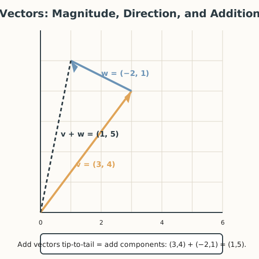
- Worked example — add tip-to-tail (15 min). Add v = (3, 4) and w = (−2, 1): draw v, then start w at v’s tip. The resultant runs from the start of v to the tip of w. In components: (3 + (−2), 4 + 1) = (1, 5). Check the picture matches the numbers.
- Scalar multiples (8 min). Doubling v gives (6, 8): same direction, twice the length. Multiplying by −1 reverses the arrow. A scalar multiple stretches, shrinks, or reverses a vector without turning it.
- Guided practice (12 min). With a partner, add (2, −3) and (5, 4) two ways — draw tip-to-tail and add components — and confirm they agree. Then describe — aloud or in writing, sign, gesture, or AAC — a real route (e.g., across a town, down a river) as a sum of vectors.
- Retrieve and connect (5 min). Write one sentence on why “add the components” is the same as “walk the second arrow from the first arrow’s tip.”
- Close (2 min). Say — or write, sign, gesture, or use AAC to express — what a vector is, in one sentence, using the words magnitude and direction.
Differentiation
- Support: Walk the route on a floor grid first, then draw it, then write the components.
- Extension: Given a vector’s magnitude and direction, recover its components (with trigonometry), and prove that reversing both components reverses the vector.
- Number access (dyscalculia): Provide the step-2 coordinate grid pre-printed so drawing the arrows (3, 4) and (−2, 1) is placing rather than computing; offload the component addition (3 + (−2), 4 + 1) and the magnitude squaring (3² + 4²) to a partner or calculator; and take the verbal route — walk “three east, four north, then two west” on a floor grid and say where you end up, describing tip-to-tail in words or gesture without writing coordinates.
- Communication access: Every spoken step — saying, naming, reading aloud, discussing, or closing — can be done in writing, sign, gesture, or AAC instead. Learners who are non-speaking, d/Deaf, hard-of-hearing, or who use AAC complete every task in their preferred mode; no step requires producing or hearing sound.
Assessment
- Formative (peer + self): Can the learner draw a vector from components, add two vectors tip-to-tail and by components, and check that the two agree?
- Portfolio artifact (unit): A drawn vector sum with its component arithmetic, in the math journal.
Home connection
Describe one trip you took today (or one animal’s movement you saw) as a sum of vectors — “two blocks east, then one north.” Write the components and the resultant, and one sentence on where you ended up.
Resources
- On worked examples and guided practice: Kirschner, Sweller & Clark (2006) (S-011).
- On coordinates and grids across traditions: MacTutor History of Mathematics (S-240).