Lesson 06 — Trade Networks: The Silk Roads & Indian Ocean Routes
Learners analyze how **long-distance trade networks** — the **Silk Roads** overland and the **Indian Ocean routes** by sea — connected peoples and moved **goods, ideas, and beliefs**. They build a labeled trade-network map as a portfolio artifact.
Objectives
Objectives
- D08.S3.08.01 Analyze how long-distance trade networks, such as the Silk Roads or Indian Ocean routes, connected peoples and moved goods, ideas, and beliefs.
Essential question
How did long-distance trade networks connect peoples and move goods, ideas, and beliefs?
Key vocabulary
Materials
Standard materials
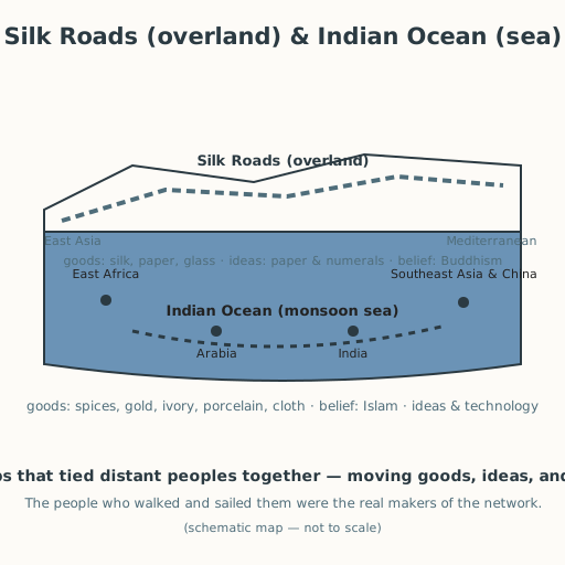
- Trade-network map sheet · 1 per learner A schematic map of the Silk Roads (overland) and Indian Ocean routes (sea) to label with goods, ideas, and beliefs that moved
- What-moved cards · 1 set per group Cards naming goods (silk, spices, porcelain, gold, ivory), ideas (paper, numerals), and beliefs (Buddhism, Islam) to place on the network
Low-tech / no-cost
- A shared board or large paper Draw the two networks together and place the "what moved" items by hand
- Voice and memory Retell what moved along each network aloud, with no printed map needed
- String, rope, or sticks (tactile map) Lay the overland and sea routes on a table or the floor with string or rope, so the networks can be traced by hand; a partner can also describe the map aloud while the learner traces it
Enriched / lab & device
- A digital or printed world map · 1 per group A real world map on which to trace the overland and sea routes
- Images of caravan and dhow · 1 set Pictures of a camel caravan and a dhow with a lateen sail, to compare overland and sea travel
Works in different contexts
- large-group Trace the networks once on a large shared map, then small groups place the cards and label their sheets
- multi-age Younger learners match each good, idea, or belief to the route that carried it; older learners explain how the network connected peoples, not just moved things
- self-directed A learner labels the map sheet and writes a short paragraph on one idea or belief that traveled and what it changed
- level-grouped Learners ready to extend add a third network or route (for example, trans-Saharan or the Inka road system) and compare
- outdoor-only Trace a local road or river as a "network" and ask what travels along it today — goods, ideas, people
Lesson 6 — Trade Networks: The Silk Roads & Indian Ocean Routes
Summary
Learners analyze how long-distance trade networks — the Silk Roads overland and the Indian Ocean routes by sea — connected peoples and moved goods, ideas, and beliefs. They build a labeled trade-network map as a portfolio artifact.
Objectives
- Analyze how long-distance trade networks, such as the Silk Roads or Indian Ocean routes, connected peoples and moved goods, ideas, and beliefs. (D08.S3.08.01)
Connection
Imagine a single road or sea lane that carries not only boxes of things but also new words, new recipes, new ideas about how to live, and new beliefs. That is what a trade network is: not just a path for goods, but a web that ties distant peoples together. Today you trace two of the greatest webs in human history — one across deserts and mountains, one across a monsoon sea — and see what traveled along them.
Materials
- Trade-network map sheet
- What-moved cards
Preparation
- Copy the trade-network map sheet and the what-moved cards.
- Retrieval: from Grade 7, recall that geography (rivers, oceans, deserts, mountains) connected or separated peoples and shaped the spread of ideas and goods (D08.S3.07.02); from Grade 6, recall the voyage of Zheng He across the Indian Ocean.
Facilitator note
This lesson is written to the learner (“you”). The idea to land: long-distance trade networks connected peoples across vast distances and moved not only goods but ideas and beliefs. The two networks: (1) the Silk Roads — overland routes across Central Asia linking East Asia (China) with the Mediterranean world, carrying silk, spices, paper, and glass, and moving Buddhism from India into Central and East Asia and paper and the decimal numerals westward (S-323, S-317, S-318, S-264). (2) the Indian Ocean routes — a sea network driven by the monsoon (a seasonal wind that reverses direction), sailed by dhows with lateen sails, linking East Africa, Arabia, India, Southeast Asia, and China, carrying spices, gold, ivory, porcelain, and cloth, and moving Islam, other beliefs, and later technologies across the ocean (S-207, S-323, S-265). The Ming Chinese fleets of Zheng He (1405–1433) sailed this network as far as Arabia and East Africa (S-265, S-264). The global lens: these networks made the medieval world far more connected than a one-region story suggests — goods and ideas crossed between China, India, Persia, East Africa, and beyond. The technology lens: the network itself was shaped by technology — camel caravans and oasis stops on land, the dhow and the monsoon calendar at sea. The ethics lens: exchange was mostly mutual and peaceful, but we are honest that not all movement was free (later in this unit we face the slave trade that some routes later carried). The egalitarian lens: the people who actually moved the goods — caravan guides, sailors, porters, merchants of many languages — were the real makers of the network, often left unnamed in old records; we name them. Keep it honest: this is documented history, told as connection, not as one people’s triumph (philosophy §11).
Procedure
- Recall (5 min). From Grade 7: how did oceans, rivers, deserts, and mountains connect or separate peoples? Today we trace two great webs that connected them.
- Meet the Silk Roads (10 min). The Silk Roads were overland routes across Central Asia, linking East Asia and the Mediterranean. Camel caravans carried silk, spices, paper, and glass. But they carried more than goods: Buddhism traveled from India into Central and East Asia, and paper and the decimal numerals traveled westward (S-323, S-317, S-318).
- Meet the Indian Ocean routes (10 min). The Indian Ocean was crossed by dhows with lateen sails, riding the monsoon — a wind that reverses with the seasons. This sea network linked East Africa, Arabia, India, Southeast Asia, and China, moving spices, gold, ivory, porcelain, and cloth — and carrying Islam and other beliefs. The fleets of Zheng He (1405–1433) sailed it from China to Arabia and East Africa (S-207, S-265).
- Build your map (15 min). On the map sheet, label the two networks and place the what-moved cards: goods (silk, spices, porcelain, gold, ivory), ideas (paper, numerals), beliefs (Buddhism, Islam). Show which traveled overland, which by sea, and which by both. (No map sheet? Lay the two routes in string or rope on a table or the floor, trace them by hand, and place the cards along them. A partner can also name each route aloud while you trace it — the map can be felt and heard, not only seen.)
- Explain the connection (10 min). Write two sentences: what did these networks move, and how did they connect peoples (not just places)? Then share with a partner.
- Close (5 min). Long before any modern “globalization,” the world was already connected — by the people who walked, sailed, and traded.
Differentiation
- Support: Provide the map pre-labeled with the two routes and ask learners to place the cards on the correct route.
- Extension: Add a third route or network — the trans-Saharan routes, or the Inka road system — and name one thing it moved.
Assessment
- Formative (observation): Can the learner place goods, ideas, and beliefs on the correct network and state how the networks connected peoples?
- Portfolio artifact: The labeled trade-network map, kept in the portfolio.
Home connection
Look at one item at home and ask: what route might it have traveled to reach you — and what ideas or beliefs traveled along routes like that long ago?
Resources
- On the Silk Roads and Indian Ocean trade: Encyclopaedia Britannica, “Silk Road” / Indian Ocean trade, https://www.britannica.com/topic/Silk-Road-trade-route (S-323).
- On the Indian Ocean as a shared maritime space: UNESCO, “The Indian Ocean, a shared heritage,” https://www.unesco.org/en/silk-roads (S-207).
- On Zheng He’s voyages: UNESCO Silk Roads Programme (Maritime Silk Road), https://www.unesco.org/en/silk-road (S-265); British Library, history of writing materials and primary sources (S-264).
- On paper and the decimal numerals traveling with trade: Britannica “Paper / Papermaking” (S-317) and “Zero / Hindu-Arabic numerals” (S-318).
- On explicit instruction and worked examples: Kirschner, Sweller & Clark (2006), https://doi.org/10.1207/s15326985ep4102_1 (S-011).