Lesson 06 — Rivers, Mountains, and Where People Settle
Learners explain how rivers, mountains, and climate shaped where people chose to settle — rivers giving water and travel, mountains giving terraced slopes, dry climates drawing people to oases — honoring each settlement as a wise, fitting answer to the land.
Objectives
Objectives
- D08.S3.03.02 Explain how rivers, mountains, or climate shaped where people chose to settle and live.
Essential question
How did rivers, mountains, or climate shape where people chose to settle and live?
Key vocabulary
Materials
Standard materials
- "Land shapes where we live" picture cards · 1 set Three cards — a riverside village, mountain terraces, a desert oasis — plus a matching "reason" card for each (water and travel; terraces to grow on slopes; water where it is dry)
- A three-part chart · 1 per learner or pair Spaces for river, mountain, and climate, with room to draw the settlement and write how the land shaped it
- Pencils and crayons · per learner For drawing the settlements and reasons
Low-tech / no-cost
- Found objects and sand or dirt Make a little river in the sand, pile stones into a mountain, and show where people would settle and why
- Body and voice Act out settling — scooping water from a river, stepping up terraces, sheltering in the shade of an oasis
Enriched / lab & device
- A picture book or photo set of river valleys, mountain terraces, and oases · 1 To see real settlements shaped by land and climate
- A globe, map, or atlas · 1 To point to great rivers, mountain ranges, and deserts and ask where people settled
Works in different contexts
- large-group Match the settlement cards to their reason cards on a big chart, the whole group calling out "water!", "slopes!", or "shade!" for each
- self-directed The learner matches the cards and fills the chart alone, then tells a grown-up or peer one way the land shaped where people settled
- outdoor-only Look at the real land around you — a stream, a slope, a shady or sunny spot — and talk about where people would choose to settle and why
- multi-age Older learners read the reason cards and scribe, while younger learners place the settlement cards and act each one
- level-grouped Learners who finish early coach peers by asking "what does this place give people? why live here?" rather than telling
Lesson 6 — Rivers, Mountains, and Where People Settle
Summary
Learners explain how rivers, mountains, and climate shaped where people chose to settle and live: rivers give water, food, and a way to travel; mountains give terraced slopes to farm; a dry climate draws people to oases and valleys where water is. Grade 2 met environments and adaptations; Grade 3 asks the next question — why here? — and finds the answer in the land itself.
Objectives
- Explain how rivers, mountains, or climate shaped where people chose to settle and live. (D08.S3.03.02)
Connection
Why do people live here and not there? Look at the land for the answer. People settle beside a river because it gives water to drink, fish to eat, and a road to travel on. People settle on mountain slopes, cutting flat steps called terraces to grow food. And where the climate is dry, people settle beside an oasis or a valley where water is. The land shapes where we live — and people have read the land with care for thousands of years.
Materials
- “Land shapes where we live” picture cards (riverside village, mountain terraces, desert oasis) with matching reason cards
- A three-part chart (river, mountain, climate)
- Pencils and crayons
Preparation
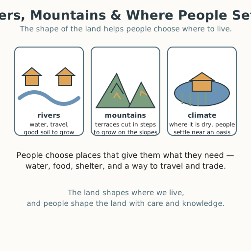
- Prepare the cards. Rivers: a village beside a river — reason: water, travel, and good soil. Mountains: terraces cut in steps on a slope — reason: flat steps to grow food on steep land. Climate: homes beside an oasis in the desert — reason: water where it is dry. (See Resources.)
- Prepare the three-part chart, and be ready to model: “People settle by the river because it gives water and a way to travel.”
Facilitator note
This lesson is written to the learner (“you”). The skill is explaining “why here,” so model one full example first (Kirschner, Sweller & Clark, 2006): “Look at the river. People settle beside it because it gives water to drink, fish to eat, and a road to travel. The river shaped where the settlement is.” Then guide the mountain and climate examples. Keep it global and true: many of the world’s great cities grew on rivers, and people have terraced mountain slopes and settled oases across every continent (see Resources) — this is a pattern of all peoples, not one region. Never rank: a mountain terrace farm is not “worse” than a river plain; each is a wise, fitting answer to its land. Honor every body: describe the cards in words for a learner who cannot see them; a learner who does not use a speaking voice points or acts. Where possible, connect to the learner’s own place — the river, slope, or climate near home is the truest example of all.
Procedure
- Gather (5 min). Look around your own place in your mind. Is there a river, a hill, a mountain, a dry or rainy season? How do you think it shaped where people built their homes?
- Meet the land (10 min). A river gives water, food, and a way to travel. A mountain is high and steep, but its slopes can be farmed in steps. Climate is the weather of a place over time — hot or cold, wet or dry.
- See how each shapes settlement (15 min). Match each settlement to its reason:
- Rivers: people settle beside the river — water, travel, and good soil to grow.
- Mountains: people cut terraces — flat steps — to grow food on the slopes.
- Climate: where it is dry, people settle near an oasis or a valley with water.
- Explain one “why here” (10 min). Choose one. Say it in your own words: “People settled here because the river gives…” or “People farmed the mountain by cutting…” Point, act, draw, or sign.
- Close (5 min). The land shapes where we live, and people have read the land with knowledge for thousands of years. Reading the land is a human gift.
Differentiation
- Support: Meet only rivers, and finish one sentence together — “People settle by rivers because…” — with picture support.
- Support (blind/low-vision): Feel objects — a cup of water (river), a raised step (terrace), shade (oasis) — and describe why each place draws people.
- Support (non-speaking): Match the settlement cards to the reason cards and point to the “why here” spot instead of speaking.
- Support (Deaf/HH): The cards are visual — match them and sign “river,” “mountain,” “water,” and “settle” as you go.
- Support (motor-difference): Use larger cards and a stable chart; direct a partner to place each card while you point, sign, or eye-gaze.
- Extension: Choose a fourth land shape — a coast, a forest, a grassland — and tell one way it shaped where people settled.
Assessment
- Formative (observation): Can the learner match each land shape — river, mountain, climate — with one way it shaped settlement?
- Formative (oral/performance): Does the learner explain, for one place, why the land shaped where people settled — in their own words, without ranking any settlement as better?
Resources
- National Geographic Education, “River” — describes how rivers provide water, food, and transport, and notes that river deltas and floodplains (valleys) are highly fertile zones that attract settlement, so many towns and cities grew beside rivers. https://education.nationalgeographic.org/resource/river/
- International Potato Center (CIP), “Potato” — notes the potato was domesticated in the Andes, where people built terraces to farm the steep mountain slopes, supporting the mountain-terrace example. https://cipotato.org/potato/
Home connection
Look at your own place with a grown-up: is there a river, a slope, a dry or rainy season? Ask where people first settled nearby and why — and tell them how you think the land shaped that choice.