Lesson 07 — Land, Water, and Where People Settled
Learners read a simple map to locate major landforms — mountains, deserts, river valleys, coasts — and bodies of water, and explain how each shaped where and how people lived: rivers for water and farm soil, coasts for fish and trade, mountain slopes for terraces, and desert oases for water. They see that people and place are always connected.
Objectives
Objectives
- D08.S3.04.01 Use maps to locate major landforms and bodies of water and explain how they shaped where and how people lived.
Essential question
How do maps help us locate landforms and bodies of water, and how did they shape where and how people lived?
Key vocabulary
Materials
Standard materials
- A simple landforms-and-water map · 1 per learner or pair A schematic map with mountains, a desert, a river valley, a coast, and an ocean, labeled, with blank circles for settlement dots
- Settlement reason cards · 1 set Fresh water and farm soil; fish and trade by sea; terraces on slopes; an oasis in the desert — matched to places
- Pencils and crayons · per learner For marking settlements and their reasons
Low-tech / no-cost
- Ground map in sand or soil Draw mountains, a river, and a sea in the ground and place stones where people might settle, saying why for each
- Body and voice Walk the "landscape" of the room or yard, standing where a mountain, river, and coast would be, and say why people settled there
Enriched / lab & device
- A real world map or globe · 1 Optional — locate the Andes, the Nile, the Indus, and a coast, and point to real settlements
- A tablet or projector · 1 per group Optional — satellite or relief images of mountains, rivers, and coasts
Works in different contexts
- large-group Build one big floor map together; the whole group places stones on the river, coast, and mountains and names the reason for each
- self-directed The learner marks settlement dots and writes or says why people settled each spot, then checks against the reason cards
- outdoor-only Draw a map in sand or soil and stand found objects where people might settle, saying why for each
- multi-age Older learners read the labels and scribe the reasons, while younger learners place the dots and act each place's life
- level-grouped Learners who finish early coach peers by asking "what does this place give people, and why settle here?" rather than telling
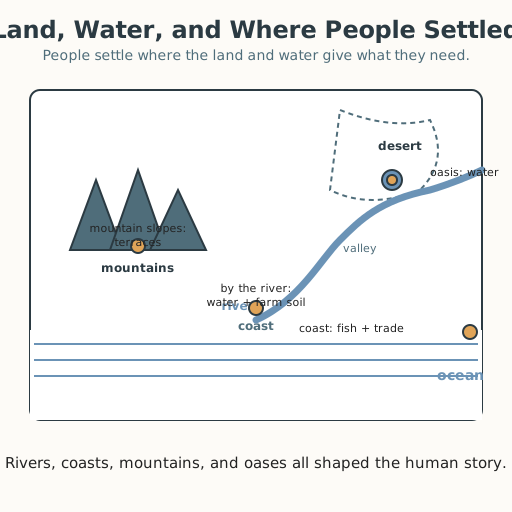
Lesson 7 — Land, Water, and Where People Settled
Summary
Learners read a simple map to locate major landforms — mountains, deserts, river valleys, coasts — and bodies of water — oceans, rivers, lakes — and explain how each shaped where and how people lived. Rivers gave fresh water and fertile soil; coasts gave fish and sea trade; mountain slopes became terraced fields; desert oases made settlement possible. The lesson shows that people and place are always connected.
Objectives
- Use maps to locate major landforms and bodies of water and explain how they shaped where and how people lived. (D08.S3.04.01)
Connection
Look at any map and you will see the land is not all the same: there are mountains, deserts, rivers, and seas. People do not settle just anywhere — they settle where the land and water give them what they need. A river brings water to drink and rich soil to farm; a coast brings fish and boats for trade. Reading a map is reading the answer to the question, “why did people make their home here?”
Materials
- A simple landforms-and-water map (one per learner or pair)
- Settlement reason cards (fresh water, fish and trade, terraces, oasis)
- Pencils and crayons
Preparation
- Prepare the schematic map with labeled features: a mountain range, a desert, a river running through a valley to the sea, a coast, and an ocean. Leave blank circles for settlement dots.
- Prepare the four reason cards.
Facilitator note
This lesson is written to the learner (“you”). Map reading is a foundational skill, so model one settlement fully first (Kirschner, Sweller & Clark, 2006): “The river — people settled here because the river gives fresh water to drink and fertile soil to farm, and boats can travel on it.” Then guide the coast, mountains, and oasis. Keep the framing global and egalitarian: river valleys (the Nile, the Indus, the Tigris–Euphrates, the Yellow, the Niger), coasts and islands (Pacific and Indian Ocean peoples), mountain terraces (the Andes), and desert oases are all real, clever human answers — never “better” or “worse” places, and never “advanced” vs. “backward.” Every place asks something of its people, and every people answers with knowledge. Honor every body: describe the map in words for a learner who cannot see it; a learner who does not use a speaking voice points or places a dot. If learners live near a landform or water body, anchor the lesson there first.
Procedure
- Gather (5 min). Think of the place where you live: is there a river, a sea, a mountain, or flat land nearby? What does it give the people there?
- Meet the map (10 min). Look at the map. Point to each feature and name it: the mountains, the desert, the river and its valley, the coast, and the ocean.
- Place the settlements (20 min). One by one, decide where people settle and why:
- By the river: fresh water to drink, fertile soil to farm, boats to travel.
- On the coast: fish to eat and boats for trade across the sea.
- On the mountain slopes: people cut flat terraces into the slopes to farm.
- At a desert oasis: a spring of water makes life possible in the dry land. For each, place a dot and match the reason card.
- Name one place and its reason (10 min). Choose one landform or water body and say or write how it shaped where people lived and how.
- Close (5 min). Land and water shaped the human story. People read their landscape and made their homes where it could care for them — and they cared for it in return.
Differentiation
- Support: Place just the river and coast settlements with heavy picture support and one shared sentence said together.
- Support (blind/low-vision): Feel a raised map or use real objects (a stone for a mountain, a bowl of water for a river) and describe where people settle and why.
- Support (non-speaking): Place the dots and point to the reason cards, instead of speaking.
- Support (Deaf/HH): The map is visual — place the dots and sign “river,” “coast,” “mountain,” and “desert” as you go.
- Support (motor-difference): Use a large, stable map and bigger dots; point or eye-gaze while a partner places each dot.
- Extension: Add a second settlement to one landform (a port town and a fishing village on the coast) and say how each lives differently.
Assessment
- Formative (observation): Can the learner locate the landforms and bodies of water on the map and place settlements sensibly?
- Formative (oral/performance): Does the learner explain how one landform or water body shaped where and how people lived — by speaking, signing, writing, or acting?
Resources
- National Geographic Education, “River” — rivers provide drinking water, irrigation, and transport, and their floodplains are fertile places people settle. https://education.nationalgeographic.org/resource/river/
- National Geographic Education, “Map” — what maps are and how they show land and water. https://education.nationalgeographic.org/resource/map/
Home connection
Look at a map of your region (paper or on a screen) and find the nearest river, coast, mountain, or lake. Ask someone: “Did people settle here because of it?” Talk about how the land and water shaped your place.