Lesson 09 — Graphing Points to Solve Location and Distance Problems
Learners graph points in the first quadrant and use them to solve location and distance problems. When two points share the same y-coordinate they find the horizontal distance; when they share the same x-coordinate they find the vertical distance — by counting units along the grid line.
Objectives
Objectives
- D05.S3.05.01 Graph points in the first quadrant of a coordinate grid and use them to solve problems about location and distance.
Essential question
How do I use plotted points to find locations and distances on a grid?
Key vocabulary
Materials
Standard materials
- First-quadrant grid · 1 per pair A numbered grid for plotting points and measuring distances along grid lines
- Location and distance cards · 1 set per group Cards with two points to plot and a distance question (e.g., well at (1,2), gate at (4,2))
- Distance recording page · 1 per learner A page for recording plotted points and the distances between them
Low-tech / no-cost
- A chalk or dirt grid Draw a grid on the ground and walk the distance between two points, counting steps along the lines
- String and pebbles Use string as grid lines and pebbles as points; count the units between pebbles along a line
Enriched / lab & device
- A digital map with a grid · 1 per group A local map overlaid with a grid to find real distances between places, where devices allow
- A coordinate distance game · 1 per group A game where partners place two points and challenge each other to find the distance
Works in different contexts
- large-group Plot two points and measure a distance together, then have pairs plot and measure their own and share one result
- multi-age Younger learners count units along one line while older learners find distances where points share an x- or y-coordinate
- self-directed A learner works the recording page alone, plotting points and computing distances by counting units
- level-grouped Learners ready to extend find distances between points that share a coordinate and describe a shortest path along grid lines
- outdoor-only Mark two points on a chalk grid on the ground and pace the distance along the grid lines, counting steps
Lesson 9 — Graphing Points to Solve Location and Distance Problems
Summary
Learners graph points in the first quadrant and use them to solve location and distance problems. When two points share the same y-coordinate, they find the horizontal distance; when they share the same x-coordinate, they find the vertical distance — by counting units along the grid line.
Objectives
- Graph points in the first quadrant and use them to solve problems about location and distance. (D05.S3.05.01)
Connection
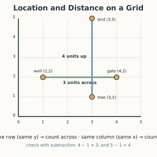
On a village map, the well is at (1,2) and the gate is at (4,2) — same row, so the distance between them is just the 3 units across. The tree is at (3,1) and a bird is at (3,5) — same column, so the distance is the 4 units up. When two places share a row or a column on a grid, their distance is a simple count — the same idea a delivery rider, a farmer, or a hiker uses to figure out how far apart two spots are.
Materials
- First-quadrant grid
- Location and distance cards
- Distance recording page
Preparation
- Copy grids for pairs and distance cards for groups.
- Copy the recording page.
- Have worked examples ready: (1,2) to (4,2) is 3 units; (3,1) to (3,5) is 4 units.
Facilitator note
This lesson is written to the learner (“you”). The ideas to land: (1) same y-coordinate →
the two points sit on a horizontal line, so the distance is the difference in x (|4 − 1| = 3);
(2) same x-coordinate → the points sit on a vertical line, so the distance is the
difference in y (|5 − 1| = 4). Emphasize counting units along the grid line and connecting it
back to subtraction. Model a worked example first, then guide a second (Kirschner, Sweller &
Clark, 2006). Common slip: mixing up x and y, or counting the spaces wrong (count the gaps, not
the points). Retrieval: ask learners to recall “across first, then up” from Lesson 7 and reuse
it. Coordinates are evidence; the habit of measuring distance honestly (not guessing) is a
critical-thinking value (docs/philosophy.md §7).
Procedure
- Gather (5 min). Recall: how do you plot the ordered pair (2,3)? Today you use plotted points to answer “how far apart are these two places?”
- The key idea (5 min). On a grid, if two points share the same y (same row), their distance is across (horizontal). If they share the same x (same column), their distance is up or down (vertical). Count the units along the line.
- Worked example — horizontal (10 min). Plot the well at (1,2) and the gate at (4,2). They share y = 2, so they are on the same row. Count across from 1 to 4: 3 units. Check with subtraction: 4 − 1 = 3.
- Worked example — vertical (10 min). Plot the tree at (3,1) and the bird at (3,5). They share x = 3, so they are on the same column. Count up from 1 to 5: 4 units. Check: 5 − 1 = 4.
- Practice with a partner (15 min). Take your distance cards. Plot both points, say whether they share an x or a y, count the units along the line, and record the distance. Check each other: did you count the gaps between the points?
- Close (5 min). Distance on a grid is a count — across when the rows match, up when the columns match. Plot first, then count carefully.
Differentiation
- Support: Use points close together (distance 1–3) that share a coordinate; keep a large grid and count aloud. Use tactile grid lines so learners with low vision can follow by touch.
- Extension: Find the distance between points that share a coordinate across a wider range, and describe a shortest path along grid lines between two points that share neither.
Assessment
- Formative (observation/self): Can the learner plot two points and find the horizontal or vertical distance between them by counting units and by subtracting coordinates?
- Self-check: The learner asks, “Do the points share an x or a y? Did I count the gaps correctly, and does my subtraction match?”
Home connection
On any grid you see (tiles, a map, a game), pick two spots in the same row or column and figure out how many units apart they are.
Resources
- Coordinate distance in the first quadrant is standard in elementary mathematics; see John A.
Van de Walle, Elementary and Middle School Mathematics (10th ed., 2019). The habit of honest
measurement is a critical-thinking value (
docs/philosophy.md§7).