Lesson 10 — More Location and Distance with Coordinates
Learners use coordinates to solve more location and distance problems: they plot rectangles, find side lengths from coordinates, and compute perimeters and the lengths of paths along grid lines. This deepens the coordinate grid as a tool for describing space.
Objectives
Objectives
- D05.S3.05.01 Graph points in the first quadrant of a coordinate grid and use them to solve problems about location and distance.
Essential question
How do I use coordinates to find distances, paths, and perimeters on a grid?
Key vocabulary
Materials
Standard materials
- First-quadrant grid · 1 per pair A numbered grid for plotting shapes and measuring side lengths and paths
- Shape and path cards · 1 set per group Cards with rectangle corners or paths to plot and measure (e.g., a field with corners (1,1),(5,1),(5,4),(1,4))
- Distance and perimeter recording page · 1 per learner A page for recording plotted shapes, side lengths, perimeters, and path lengths
Low-tech / no-cost
- A chalk or dirt grid Draw a rectangle on a ground grid and pace its sides; add the four side lengths to find the perimeter
- String around a shape Mark the corners of a rectangle with pebbles on a string grid, then measure each side with a piece of string
Enriched / lab & device
- A digital map with a grid · 1 per group A local map to find the perimeter of a real field or park and the length of a walking path, where devices allow
- A coordinate perimeter game · 1 per group A game where partners plot rectangle corners and challenge each other to find the perimeter
Works in different contexts
- large-group Build one rectangle and find its perimeter together, then have pairs plot shapes and paths and share one result
- multi-age Younger learners count side lengths of a plotted rectangle while older learners compute perimeters and multi-leg paths
- self-directed A learner works the recording page alone, plotting shapes and computing perimeters and path lengths
- level-grouped Learners ready to extend find the perimeter of a rectangle from its four corner coordinates and a shortest path along grid lines between two far points
- outdoor-only Lay out a real rectangle on a ground grid, pace each side, and add the lengths to find the perimeter
Lesson 10 — More Location and Distance with Coordinates
Summary
Learners deepen their coordinate skills by plotting rectangles, finding side lengths from coordinates, and computing perimeters and the lengths of paths along grid lines. They connect coordinates back to the measurement work of the unit.
Objectives
- Graph points in the first quadrant and use them to solve problems about location and distance, including the perimeter of a rectangle. (D05.S3.05.01)
Connection
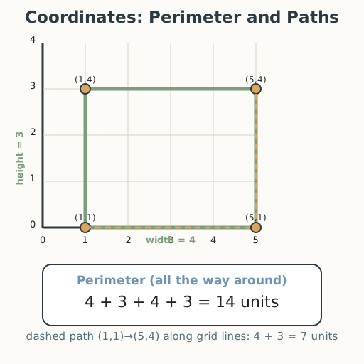
A community garden plots a rectangle of land for planting. Its four corners are at (1,1), (5,1), (5,4), and (1,4). To fence it, the gardeners need the perimeter — the distance all the way around. From the coordinates they read the sides: 4 units across and 3 units up, so the fence is 4 + 3 + 4 + 3 = 14 units. Coordinates turn a drawing into numbers a builder, a farmer, or a town planner can use to plan a fence, a path, or a plot of land.
Materials
- First-quadrant grid
- Shape and path cards
- Distance and perimeter recording page
Preparation
- Copy grids for pairs and shape/path cards for groups.
- Copy the recording page.
- Have worked examples ready: rectangle (1,1),(5,1),(5,4),(1,4) → perimeter 14; path length.
Facilitator note
This lesson is written to the learner (“you”). The ideas to land: (1) a rectangle’s side lengths
come from the differences of its coordinates — width = difference in x, height = difference in
y; (2) perimeter = add all four side lengths (or 2 × width + 2 × height); (3) a path along
grid lines is found by adding each leg’s length. Model a worked example first, then guide a
second (Kirschner, Sweller & Clark, 2006). Retrieval: ask learners to recall Lesson 9’s
“same row / same column” distance rule and reuse it here. Common slip: adding only two sides
instead of all four for perimeter, or miscounting units. Coordinates are evidence; the fairness
value appears in planning shared space so everyone’s plot is measured honestly and equally
(docs/philosophy.md §4).
Procedure
- Gather (5 min). Recall: how far apart are (1,2) and (4,2)? Today you use coordinates to find perimeters and paths — the math of fencing and planning land.
- Plot a rectangle (10 min). Plot the garden’s corners: (1,1), (5,1), (5,4), (1,4), and connect them to make a rectangle. Read the side lengths from the coordinates: the bottom side goes from x = 1 to x = 5, so it is 4 units across; the left side goes from y = 1 to y = 4, so it is 3 units up.
- Find the perimeter (10 min). The perimeter is the distance all the way around: **4 + 3 + 4
- 3 = 14 units**. Check with the short rule: 2 × 4 + 2 × 3 = 8 + 6 = 14.
- Measure a path (10 min). To walk from (1,1) to (5,4) along the grid lines, you go across then up — or up then across. Count the legs: 4 + 3 = 7 units. Draw the path.
- Practice with a partner (10 min). Take your shape and path cards. Plot each shape, read its side lengths, find the perimeter, and measure the path. Check each other: did you add all four sides? Did you count each leg of the path?
- Close (5 min). Coordinates let you measure space without a ruler — the numbers tell you the lengths. That is how maps and plans become real fences, roads, and gardens.
Differentiation
- Support: Use small rectangles (2 by 3) and read side lengths aloud; keep the grid large and tactile so learners with low vision can follow by touch.
- Extension: Find the perimeter of a rectangle from coordinates alone (no drawing), and find the shortest path along grid lines between two far-apart points.
Assessment
- Formative (observation/self): Can the learner read side lengths from coordinates and compute a rectangle’s perimeter and a path’s length correctly?
- Self-check: The learner asks, “Did I add all four sides for the perimeter, and did I count every leg of the path?”
Home connection
Find a rectangular space (a rug, a room, a garden bed) and use coordinates or steps to measure its sides, then add them to find the distance around it.
Resources
- Perimeter via coordinates is standard in elementary mathematics; see John A. Van de Walle,
Elementary and Middle School Mathematics (10th ed., 2019). The fairness value of measuring
shared space equally is a commitment (
docs/philosophy.md§4).