Lesson 11 — Polygons on the Coordinate Plane: Position
Learners draw polygons on the four-quadrant coordinate plane by plotting their vertices as ordered pairs and connecting them in order. They name the quadrant of each vertex and see how positive and negative coordinates place a polygon anywhere on the plane.
Objectives
Objectives
- D05.S3.06.02 Draw and use polygons on the coordinate plane to solve real problems involving position and length.
Essential question
How do I draw a polygon on the coordinate plane using its vertices?
Key vocabulary
Materials
Standard materials
- Four-quadrant grid · 1 per pair A grid numbered -4 to 4 on both axes with labeled quadrants
- Polygon vertex cards · 1 set per group Cards listing the ordered pairs of a polygon's vertices to plot and connect
- Recording page · 1 per learner A page with blank four-quadrant grids to draw polygons and name their positions
Low-tech / no-cost
- A chalk four-quadrant grid Draw axes on the ground with 0 in the middle; walk to vertices and stretch string to form the polygon
- Body coordinates Learners stand at the vertices of a polygon on a floor grid, naming their ordered pairs and quadrants
Enriched / lab & device
- A digital graphing tool · 1 per group A tool that plots vertices and draws polygons in all four quadrants, where devices allow
- A map with a grid · 1 per group A real map overlaid with a grid, to find places (and shapes) by coordinates in all directions
Works in different contexts
- large-group Draw one polygon together on a big grid at the front, then have pairs plot vertices and connect them
- multi-age Younger learners plot single vertices in one quadrant while older learners draw full polygons across quadrants
- self-directed A learner plots each polygon alone from the vertex cards, connects the points, and checks the shape
- level-grouped Learners ready to extend name the quadrant of each vertex and predict where a reflected vertex would fall
- outdoor-only Draw a four-quadrant grid in the dirt or chalk; walk to each vertex and stretch string to make the polygon
Lesson 11 — Polygons on the Coordinate Plane: Position
Summary
Learners draw polygons on the four-quadrant coordinate plane by plotting their vertices as ordered pairs and connecting them in order. They name the quadrant of each vertex and see how positive and negative coordinates place a polygon anywhere on the plane.
Objectives
- Draw a polygon on the coordinate plane using its vertices’ ordered pairs and describe its position. (D05.S3.06.02)
Connection
A surveyor maps a plot of land by marking its corners as coordinates, then joins the corners into a shape; a navigator fixes a route the same way, and a game designer places a character’s path by its points. When the plane grows beyond one corner — left of zero and below zero — polygons can live in any quadrant. Joining points by their coordinates is how mapmakers and builders in every region place real shapes on paper and on screens.
Materials
- Four-quadrant grid
- Polygon vertex cards
- Recording page
Preparation
- Copy four-quadrant grids for pairs, vertex cards for groups, and the recording page.
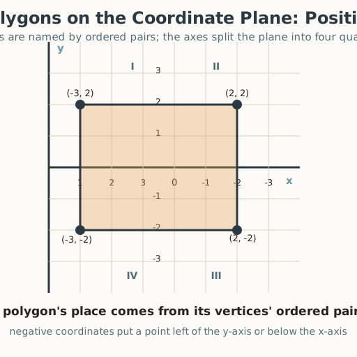
- Have a worked example ready: plot and connect (−3, 2), (2, 2), (2, −2), (−3, −2) → a rectangle.
Facilitator note
This lesson is written to the learner (“you”). The ideas to land: (1) the coordinate plane has two
axes meeting at the origin (0,0), splitting the plane into four quadrants; (2) a polygon is
drawn by plotting each vertex as an ordered pair (x, y) — across x, then up y — and connecting them
in order; and (3) the signs of x and y tell the quadrant (both positive = I, negative-x/positive-y = II,
both negative = III, positive-x/negative-y = IV). Model a worked example first, then guide a second before
independent work (Kirschner, Sweller & Clark, 2006). Two common slips: reversing the ordered pair, and
connecting vertices in the wrong order (which changes the shape). Retrieval: ask learners to recall
first-quadrant plotting from Grade 5 and signed numbers from earlier this unit — this lesson joins the two
into the full plane. The critical-thinking lens: reading coordinates exactly — not guessing — is honest
reasoning (docs/philosophy.md §7). Note the global point: coordinate grids trace to Descartes, but
locating a place by two distances (latitude and longitude, grid squares on maps) is older and appears in
surveying and navigation traditions worldwide.
Procedure
- Gather (5 min). Earlier this unit you ordered signed numbers on a line. Today you put two lines together and draw shapes anywhere on the plane.
- Meet the four quadrants (10 min). The x-axis runs across and the y-axis runs up; they meet at the origin (0,0) and split the plane into four quadrants. In quadrant I, x and y are both positive; in II, x is negative and y positive; in III, both negative; in IV, x positive and y negative.
- Worked example (10 min). Plot the rectangle’s vertices: (−3, 2), (2, 2), (2, −2), (−3, −2). For each, go across x first, then up y. Mark the point. Then connect them in order — back to the start — to close the shape.
- Name the position (10 min). Say which quadrant each vertex sits in. (−3, 2) is quadrant II (negative x, positive y); (2, 2) is quadrant I; (2, −2) is quadrant IV; (−3, −2) is quadrant III. The rectangle stretches across all four.
- Practice with a partner (10 min). Take your vertex cards, plot each polygon, connect the vertices in order, and name the quadrant of each vertex. Check each other: across first, then up, and connect in order.
- Close (5 min). A polygon lives wherever its vertices’ coordinates say. Plot each vertex, connect in order, and the signs of x and y tell you the quadrant — any shape, anywhere on the plane.
Differentiation
- Support: Start with polygons in quadrant I only, then add one vertex across an axis; use a large labeled grid and describe each move aloud so learners with low vision can follow by listening and touch.
- Extension: Reflect a vertex across an axis and predict its new coordinates; name the quadrant of each vertex of a more complex polygon.
Assessment
- Formative (observation/self): Can the learner plot a polygon’s vertices in order and name the quadrant of each vertex?
- Self-check: The learner asks, “Did I go across then up for each vertex, connect them in the right order, and name each vertex’s quadrant by its signs?”
Home connection
Draw a four-quadrant grid at home and plot a simple shape (a square, a triangle) with at least one vertex left of zero or below zero; tell someone the quadrant of each corner.
Resources
- Drawing polygons on the coordinate plane is standard in middle-grades mathematics; see John A. Van de
Walle, Elementary and Middle School Mathematics (10th ed., 2019). The note that locating by two
distances predates Cartesian coordinates and appears in global surveying and navigation is a historical
observation; reading coordinates exactly rather than guessing is a critical-thinking value
(
docs/philosophy.md§7).