Lesson 12 — Polygons on the Coordinate Plane: Length
Learners find the length of a polygon's horizontal and vertical sides on the coordinate plane by subtracting the matching coordinates — a left-right side's length is the difference of its x-values; an up-down side's length is the difference of its y-values. They check by counting grid units and add side lengths to find perimeter.
Objectives
Objectives
- D05.S3.06.02 Draw and use polygons on the coordinate plane to solve real problems involving position and length.
Essential question
How do I find the length of a side of a polygon on the coordinate plane?
Key vocabulary
Materials
Standard materials
- Four-quadrant grid · 1 per pair A grid numbered -4 to 4 on both axes for drawing polygons and measuring sides
- Side-length task cards · 1 set per group Cards with polygons whose horizontal and vertical sides need their lengths found
- Recording page · 1 per learner A page to record side lengths and perimeters found by subtracting coordinates
Low-tech / no-cost
- A chalk grid and steps Walk along a polygon's side on a floor grid, counting steps between vertices to find the length
- String and a grid Stretch string along a side and count grid spaces; compare to subtracting the coordinates
Enriched / lab & device
- A digital graphing tool · 1 per group A tool that shows side lengths and distances between plotted vertices, where devices allow
- A real measuring task · 1 per group Plot a real object's corners on a grid and find its side lengths and perimeter by subtracting coordinates
Works in different contexts
- large-group Find one side's length together at the front, then have pairs measure the sides of polygon cards and add perimeters
- multi-age Younger learners count grid squares along a side while older learners subtract coordinates and compute perimeters
- self-directed A learner works the recording page alone, finding each side's length by subtraction and checking by counting
- level-grouped Learners ready to extend find a missing vertex given a side length, and distinguish horizontal from vertical subtraction
- outdoor-only Walk the sides of a polygon drawn in the dirt, count steps, then confirm the count by subtracting the coordinates
Lesson 12 — Polygons on the Coordinate Plane: Length
Summary
Learners find the length of a polygon’s horizontal and vertical sides on the coordinate plane by subtracting the matching coordinates: a left-right side’s length is the difference of its x-values; an up-down side’s length is the difference of its y-values. They check by counting grid units and add side lengths to find perimeter.
Objectives
- Find the length of a polygon’s sides on the coordinate plane using coordinates, and use lengths to solve real problems. (D05.S3.06.02)
Connection
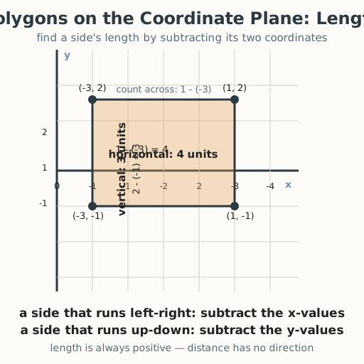
A builder laying out a rectangular courtyard has marked the corners on a site plan: one side runs from (−3, 2) to (1, 2). How long is that wall? You could walk it and count steps — or subtract: the x-values go from −3 to 1, a change of 1 − (−3) = 4 units. Reading a side’s length straight from its coordinates is how surveyors, architects, and cartographers turn a drawing into real distances, whether the plan is for a house in Lagos, a terrace farm in the Andes, or a canal in the Netherlands.
Materials
- Four-quadrant grid
- Side-length task cards
- Recording page
Preparation
- Copy four-quadrant grids for pairs, side-length task cards for groups, and the recording page.
- Have a worked example ready: side from (−3, 2) to (1, 2) → 1 − (−3) = 4 units; from (1, 2) to (1, −1) → 2 − (−1) = 3 units.
Facilitator note
This lesson is written to the learner (“you”). The ideas to land: (1) a horizontal side’s endpoints
share the same y-value, so its length is the difference of the x-values (subtract, larger minus smaller);
(2) a vertical side’s endpoints share the same x-value, so its length is the difference of the
y-values; and (3) length is always positive — distance has no direction, so we take the larger coordinate
minus the smaller (or the absolute value of the difference). Model a worked example first, then guide a
second before independent work (Kirschner, Sweller & Clark, 2006). The classic slip is subtracting in the
wrong order and getting a negative length — fix it by always saying “distance is positive.” Retrieval:
ask learners to recall yesterday’s polygon drawing and the signed numbers from earlier — subtracting
negative coordinates is where both skills meet. The critical-thinking lens: checking a subtraction against
a visual count of the grid is honest reasoning (docs/philosophy.md §7). Note the global point: reading
distance from coordinates is the same idea as reading a map’s grid, used in surveying and navigation
traditions worldwide.
Procedure
- Gather (5 min). Yesterday you placed polygons on the plane. Today you measure their sides without a ruler — using the coordinates themselves.
- Meet horizontal sides (10 min). A side that runs left-right has both endpoints at the same height (same y). Its length is the difference of the two x-values. From (−3, 2) to (1, 2): 1 − (−3) = 4 units.
- Worked example — horizontal (10 min). Check by counting: from −3 to 1 on the x-axis is 4 grid spaces. So the wall is 4 units long. The subtraction is just fast counting.
- Worked example — vertical (10 min). A side that runs up-down has both endpoints at the same x-value. From (1, 2) to (1, −1): the length is the difference of the y-values: 2 − (−1) = 3 units. Count it: 2 down to −1 is 3 spaces. Distance is always positive.
- Practice with a partner (10 min). Take your side-length cards. For each polygon, find every horizontal and vertical side’s length by subtracting the matching coordinates, then add the sides for the perimeter. Check each other by counting the grid.
- Close (5 min). A side’s length is a difference of coordinates — x-values for left-right sides, y-values for up-down sides. Subtract and take the positive amount, and you can measure a whole shape from its points alone.
Differentiation
- Support: Use polygons whose sides lie on whole-number grid lines in one quadrant; count aloud first, then match the count to the subtraction, using a large tactile grid so learners with low vision can follow by touch.
- Extension: Find a missing vertex given one vertex and a side length; find the perimeter of a polygon that crosses the axes; explain why length is always positive.
Assessment
- Formative (observation/self): Can the learner find a horizontal or vertical side’s length by subtracting the correct coordinates and get a positive result?
- Self-check: The learner asks, “Did I subtract the matching coordinates (x for left-right, y for up-down), take the positive amount, and check it by counting the grid?”
Home connection
Draw a rectangle on a grid at home, and find each side’s length both by counting squares and by subtracting its coordinates; then find its perimeter.
Resources
- Finding side lengths of polygons on the coordinate plane is standard in middle-grades mathematics; see
John A. Van de Walle, Elementary and Middle School Mathematics (10th ed., 2019). The note that reading
distance from coordinates parallels grid-based surveying and navigation traditions worldwide is a
historical observation; checking a calculation against a visual count is a critical-thinking habit
(
docs/philosophy.md§7).