Lesson 09 — Settlement, Resources, and Environmental Change
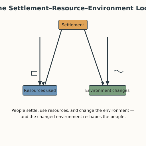
Learners analyze the three-way relationship between human settlement, resource use, and environmental change, using irrigation as a first worked example and the Ancestral Pueblo center of Chaco Canyon (S-382) and Classic Maya cities (S-378) as deeper cases. They see the loop: people settle where resources are, draw on them, and change the environment — and sometimes the changed environment changes the people in turn.
Objectives
Objectives
- D08.S3.11.01 Analyze the relationship between human settlement, resource use, and environmental change, such as deforestation or water scarcity, across regions.
Essential question
How are human settlement, resource use, and environmental change connected across regions?
Key vocabulary
Materials
Standard materials
- Settlement-resource-environment diagram sheet · 1 per learner A three-part loop — settlement, resources, environment — to trace cause and effect in a case
- History journal · 1 per learner
Low-tech / no-cost
- A drawn river and a basin of water Model irrigation — carrying water to crops — with a groove and a channel
Enriched / lab & device
- Maps of a river basin and a dryland settlement (if available) To locate the settlements and their water sources
Works in different contexts
- large-group Trace one case whole-class on the board, then pairs trace a second case on their sheets
- multi-age Younger learners name "what people took from the place" and "what changed"; older learners trace the loop and the tipping point
- self-directed A learner works the loop for one case and writes where the balance held or broke
- level-grouped A ready group reads the Chaco drought case (S-382) and names the settlement-resource-environment link
- outdoor-only Find a local example of people drawing on land and water; trace the loop where you stand
Lesson 9 — Settlement, Resources, and Environmental Change
Summary
People settle where land, water, and materials are; they use those resources; and their use changes the environment. Sometimes the loop turns back: a changed environment reshapes the settlement itself. Learners trace this three-part loop through irrigation — carrying water to crops from the Nile and Tigris-Euphrates to today (S-130) — and through the Ancestral Pueblo center of Chaco Canyon, where a long drought in the late 1200s helped push people to migrate (S-382), and the Classic Maya cities, whose decline is best explained by several pressures working together (S-378).
Objectives
- Analyze the relationship between human settlement, resource use, and environmental change across regions. (D08.S3.11.01)
Connection
Every settlement you have ever seen sits where it does for a reason: water to drink, soil to grow food, wood or stone to build with, a road or river to travel. The place gives, people take, and the place changes. That is the loop — and it runs beneath every city, village, and farm on Earth.
Materials
- Settlement-resource-environment diagram sheet
- History journal
Preparation
- Copy the three-part loop diagram sheet.
- Retrieval: from Grade 10, how societies changed and were changed by their environments over long spans of time, including adaptation and decline.
Facilitator note
The skill to land: trace a three-part loop — settlement → resource use → environmental change → back to settlement. Teach it with a worked example (irrigation), then guide practice on the Chaco and Maya cases (S-011). The environment lens: this is the unit’s core environmental reasoning. The critical-thinking lens: the Maya decline is not one cause but several working together — drought, deforestation, and warfare — and good history resists single-cause stories (S-378). The egalitarian lens: when resources run short, the burden rarely falls evenly. The global lens: the same loop runs in the Nile Valley, the Southwest, and the Maya lowlands — one human pattern, many places. Note that “decline” is not “disappearance”: Maya and Pueblo peoples are living peoples, their descendants present today.
Procedure
- Recall (5 min). From earlier grades: why do people settle near rivers and floodplains? Today we trace the full loop, not just the first step.
- The worked example: irrigation (12 min). People settled where rivers and fertile land met. To grow more, they carried water to crops — irrigation, from the Nile and Tigris-Euphrates to today (S-130). Trace the loop: settlement → using river water → changed land (more crops, but sometimes salty or waterlogged soil) → settlement adjusts.
- Case one: Chaco Canyon (12 min). The Ancestral Pueblo center of Chaco Canyon was a thriving regional center from about 850 to 1250 CE. In the late 1200s, sustained drought contributed to people migrating to new pueblos elsewhere — where their descendants live today (S-382). Fill the loop for Chaco.
- Case two: Classic Maya cities (12 min). Classic Maya cities flourished from about 250 to 900 CE. Their decline is best explained by several pressures together — warfare, exhausted soil, and drought — not one cause (S-378). Fill the loop and note where more than one arrow points at once.
- Compare the loops (10 min). With a partner: what do the three cases share? Where does the loop turn back on the people?
- Journal (4 min). Write: “Settlement, resources, and environment are one loop because…”
Differentiation
- Support: Use pre-drawn loop arrows and fill only the labels, not the whole diagram.
- Extension: Add a modern case (a growing city drawing down an aquifer) and trace the same loop.
Assessment
- Formative (peer + self): Can the learner trace the loop for a case and explain how environmental change can feed back into settlement?
- Portfolio artifact (unit): The completed loop diagrams for irrigation, Chaco, and the Maya, as the settlement-resource-environment analysis.
Home connection
Find where your home’s water comes from and where its waste and smoke go. Trace your household’s one small loop of settlement → resource use → environmental change.
Resources
- Irrigation as carrying water to crops, from the Nile and Tigris-Euphrates to today: National Geographic Education (S-130).
- Chaco Canyon as an Ancestral Pueblo center (850–1250 CE) and the drought-and-migration account: U.S. National Park Service (S-382).
- The Classic Maya (c. 250–900 CE) and the multi-cause account of decline: Encyclopaedia Britannica (S-378).
- Explicit instruction and worked examples for a new analytic skill: Kirschner, Sweller & Clark (2006) (S-011).